NOAA, local council to improve marine navigation near Valdez, Alaska
Oct 15, 2020A new Physical Oceanographic Real-Time System, also known as PORTSⓇ, aims to improve maritime safety and efficiency off Valdez, Alaska. NOAA and the Prince William Sound Regional Citizens’ Advisory Council partnered to establish the third new PORTS system this year, the 36th in the nationwide network.
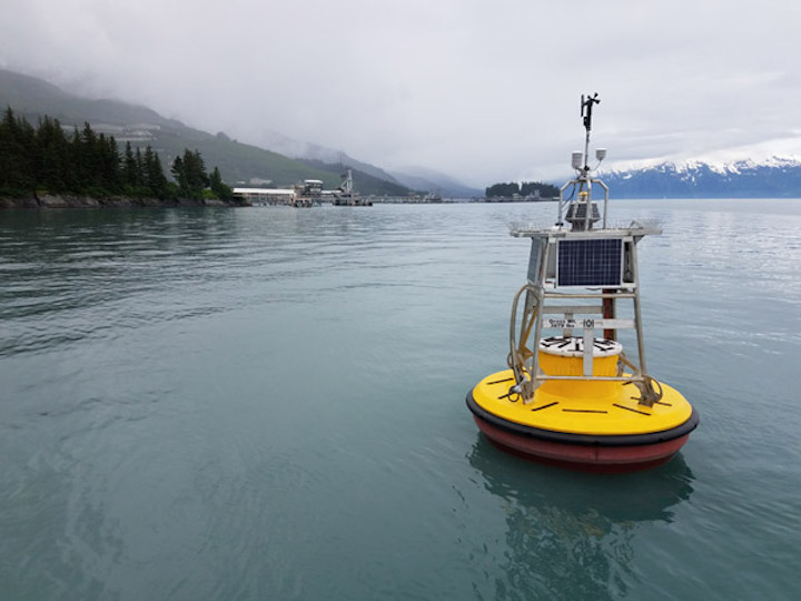
The Valdez PORTS will consist of an existing NOAA National Water Level Observation Network (NWLON) station at Valdez and two new meteorological-ocean buoys, operated and maintained by the council, that measure tidal currents, wind, air temperature, water temperature and barometric pressure.
One of the buoys is located off Jackson Point, at the Alyeska Pipeline Service Company’s Valdez Marine Terminal. The other is near the Valdez Duck Flats. In addition to maritime commerce, this information also improves natural resource management by collecting environmental data.

“This new system, and the others like them around the country, reduce ship accidents by more than 50 percent, increase the size of ships that can get in and out of seaports, and reduce traffic delays,” said Steven Thur, Ph.D., acting deputy director of NOAA’s National Ocean Service. “They also provide real-time, resilience-ready data as coastal conditions rapidly change, potentially threatening our coastal communities.”
The Port of Valdez is projected to see an increase in commercial ship traffic and passenger cruise ships in the next five to ten years. It is known as the northernmost ice-free U.S. port, where it does not freeze over in winter and is an ideal access point for goods shipped to interior Alaska locations. The Port of Valdez is located at the upper end of Prince William Sound, the site of the well known Exxon Valdez oil spill in 1989, which spilled nearly 11 million gallons of crude oil.
“While the council’s sole purpose for installing these buoys is to promote the environmentally safe operation of the Valdez Marine Terminal and associated tankers, we believe the integration of this metocean data into NOAA’s PORTSⓇ will benefit and improve safety for a variety of other maritime users,” said Donna Schantz, executive director for the council. “This is another excellent example of how collaborative science can have wide-ranging impacts for the betterment of all.”
Data from the buoys is already being provided to the Alaska Ocean Observing System, a regional association of the NOAA-led U.S. Integrated Ocean Observing System (IOOSⓇ). PORTS is leveraging that pathway to bring in the quality controlled buoy data and merge it with the Valdez NWLON data, enabling users to access all data in familiar PORTS products through one website.
The buoys were made possible through donations from Fairweather Science and partnerships with the Prince William Sound Science Center, Alyeska Pipeline Service Company, the City of Valdez and Valdez Fisheries Development Association. The installation has been permitted by several agencies, and cooperation with the U.S. Coast Guard and Alyeska Pipeline Service Company has allowed the council access into the marine security zone that borders the terminal.
PORTS is a cost-shared partnership program with local port authorities, pilot associations, the U.S. Coast Guard, the U.S. Army Corps of Engineers, the U.S. Navy, academia, and other stakeholders across the nation. In addition to other noted benefits, these systems also improve hazardous spill response and enhance recreational activities.
The first PORTS was established in 1991 in Tampa Bay following a deadly collision that occurred in 1981; an inbound freighter collided with the Sunshine Skyway Bridge, causing a bridge collapse that killed 35 people. The accident underscored the need for integrated real-time information to provide comprehensive situational awareness to mariners making safety and operational decisions.
Similar Stories

Cuxport enhances operations with new terminal operating system from Kaleris
View Article
LNG powers unprecedented year for orders of alternative-fueled vessels
View Article
Since the 2011 Fukushima accident, Japan has restarted 14 nuclear reactors
View Article
NAWE issues statement on Master Contract tentative deal
View Article
UIPA incentive supports Nucor Towers & Structures expansion in Brigham City
View Article
NRF praises tentative labor deal for East Coast, Gulf Coast ports
View ArticleGet the most up-to-date trending news!
SubscribeIndustry updates and weekly newsletter direct to your inbox!


